Akkuş
District and municipality in Ordu, Turkey
40°47′35″N 37°00′59″E / 40.79306°N 37.01639°E / 40.79306; 37.01639 (2022)[1]
52950
Akkuş is a municipality and district of Ordu Province, Turkey.[2] Its area is 697 km2,[3] and its population is 21,258 (2022).[1] The town lies at an elevation of 1,313 m (4,308 ft).[4]
Geography
Akkuş is in the foothills of Mount Argan in the Canik range inland from the Black Sea coast. Two rivers, the Tifi and the Karakuş are formed from streams running down from these mountains. The climate is typical of high pasture country, the district is under snow for four to five months of the year, and fog and rain for the remainder. The summer sun occasionally shines and when it does the lush green countryside is beautiful. The area could attract visitors on trekking or winter sports vacations but lacks the infrastructure for this at the moment. The local economy depends on farming, forestry and grazing livestock plus some handicrafts including carpet weaving.
History
Formerly known as Karakuş, the area was once part of the Kingdom of Pontus. The first Turkish rulers were the Danishmend and Hacıemiroğlu Anatolian beyliks and then from the 15th century the Ottoman Empire.
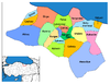
Composition
There are 44 neighbourhoods in Akkuş District:[5]
- Akpınar
- Alan
- Ambargürgen
- Çaldere
- Çamalan
- Çamlıca
- Çavdar
- Çayıralan
- Ceyhanlı
- Çökek
- Çukurköy
- Dağyolu
- Damyeri
- Düğencili
- Esentepe
- Gedikli
- Gökçebayır
- Gürgenliyatak
- Haliluşağı
- Karaçal
- Kargı
- Kemikgeriş
- Ketendere
- Kızılelma
- Koçcuvaz
- Külekçili
- Kurtboğaz
- Kuşçulu
- Merkez
- Meyvalı
- Muratlı
- Ormancık
- Ortabölme
- Şahin
- Salman
- Seferli
- Subaşı
- Tuzakköy
- Yazlıkbelen
- Yenimahalle
- Yeşilgüneycik
- Yeşilköy
- Yolbaşı
- Yukarıdüğencili
Image gallery
-
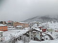 Akkus challenging winter
 -
 Argan is a square plateau


References
- ^ a b "Address-based population registration system (ADNKS) results dated 31 December 2022, Favorite Reports" (XLS). TÜİK. Retrieved 19 September 2023.
- ^ Büyükşehir İlçe Belediyesi, Turkey Civil Administration Departments Inventory. Retrieved 19 September 2023.
- ^ "İl ve İlçe Yüz ölçümleri". General Directorate of Mapping. Retrieved 19 September 2023.
- ^ Falling Rain Genomics, Inc. "Geographical information on Akkuş, Turkey". Retrieved 9 October 2023.
- ^ Mahalle, Turkey Civil Administration Departments Inventory. Retrieved 19 September 2023.
External links
Wikimedia Commons has media related to Akkuş.
- (in Turkish) District governor's official website
- (in Turkish) Local information website
- Road map of Akkuş and environs
- Various images of Akkuş, Ordu
- v
- t
- e
Akkuş in Ordu Province of Turkey

| Istanbul | |
|---|---|
| West Marmara | |
| Aegean | |
| East Marmara | |
| West Anatolia | |
| Mediterranean | |
| Central Anatolia | |
| West Black Sea | |
| East Black Sea | |
| Northeast Anatolia | |
| Central East Anatolia | |
| Southeast Anatolia | |
Metropolitan municipalities are bolded.
Authority control databases | |
|---|---|
| International |
|
| National |
|


