Osmaniye Province
Province in Turkey
Osmaniye Province Osmaniye ili | |
|---|---|
Province | |
 Castle of Amouda | |
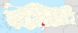 Location of the province within Turkey | |
| Country | Turkey |
| Seat | Osmaniye |
| Government | |
| • Governor | Erdinç Yılmaz |
| Area | 3,320 km2 (1,280 sq mi) |
| Population (2022)[1] | 559,405 |
| • Density | 170/km2 (440/sq mi) |
| Time zone | UTC+3 (TRT) |
| Area code | 0328 |
| Website | www |
Osmaniye Province (Turkish: Osmaniye ili) is a province in south-central Turkey. It was named Cebel-i Bereket (lit. 'Fertile Mountain') in the early republic until 1933, when it was incorporated into Adana Province. It was made a province again in 1996.[2][3] Its area is 3,320 km2,[4] and its population is 559,405 (2022).[1] The province is situated in Çukurova, a geographical, economical and cultural region. The capital of the province is Osmaniye. Other major towns include Kadirli and Düziçi.
Geography

Osmaniye Province is mainly under hot-summer Mediterranean climate (Csa) according to Köppen climate classification system.
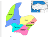
Districts

Osmaniye province is divided into 7 districts (capital district in bold):[6]
Historical sites and ruins
- Karatepe
- Kastabala ancient city
- Toprakkale Castle
- Harun Reşit Kalesi
- Kırk Kapı Kilisesi, a church
- Ala Mosque, a mosque
Notable people
- Yaşar Kemal, Turkish-Kurdish writer and human rights activist
- Devlet Bahçeli, Turkish politician and current leader of Nationalist Movement Party
- Samet Aybaba, Football manager
- Ahmet Yıldırım, Football manager
Festivals
- Karakucak Wrestling Festival - Kadirli (25–26 May)
Gallery
-
 Ancient city of Hierapolis Castabala in Osmaniye
 -
 Karatepe historic site
 -
 A view from the city of Osmaniye
 -
 A flowering plant of Nerium oleander in Kesmeburun
 -
 Corn field and irrigation canal


See also
References
- ^ a b "Address-based population registration system (ADNKS) results dated 31 December 2022, Favorite Reports" (XLS). TÜİK. Retrieved 19 September 2023.
- ^ Kanun No. 4200, Resmî Gazete, 28 October 1996.
- ^ "İl İdaresi ve Mülki Bölümler Şube Müdürlüğü İstatistikleri - İl ve İlçe Kuruluş Tarihleri" (PDF) (in Turkish). p. 69. Retrieved 25 October 2023.
- ^ "İl ve İlçe Yüz ölçümleri". General Directorate of Mapping. Retrieved 19 September 2023.
- ^ "Present and future Köppen-Geiger climate classification maps at 1-km resolution". Nature Scientific Data. DOI:10.1038/sdata.2018.214.
- ^ İlçe Belediyesi, Turkey Civil Administration Departments Inventory. Retrieved 22 May 2023.
External links
Wikimedia Commons has media related to Osmaniye Province.
- (in Turkish) Osmaniye governor's official website
- (in Turkish) Osmaniye municipality's official website
- (in Turkish) Osmaniye Haber
- (in English) Osmaniye weather forecast information
- (in Turkish) TÜİK announced, the population of Osmaniye will be 557 thousand 666 in 2023
- v
- t
- e
Osmaniye Province of Turkey

| Istanbul | |
|---|---|
| West Marmara | |
| Aegean | |
| East Marmara | |
| West Anatolia | |
| Mediterranean | |
| Central Anatolia | |
| West Black Sea | |
| East Black Sea | |
| Northeast Anatolia | |
| Central East Anatolia | |
| Southeast Anatolia | |
Metropolitan municipalities are bolded.
Authority control databases | |
|---|---|
| National |
|
| Geographic |
|
37°13′41″N 36°12′45″E / 37.22806°N 36.21250°E / 37.22806; 36.21250
 | This article about a Mediterranean Region of Turkey location is a stub. You can help Wikipedia by expanding it. |
- v
- t
- e


