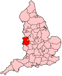
Shropshire
Unitaire autoriteit in Engeland  | |||
|---|---|---|---|
 (Details)  | |||
 | |||
| Situering | |||
| Land | Engeland | ||
| Status | ceremonieel graafschap | ||
| Regio | West Midlands | ||
| Coördinaten | 52°37'0"NB, 2°43'0"WL | ||
| Algemeen | |||
| Oppervlakte | 3197,2758[1] km² | ||
| Inwoners (2018[2]) | 320.274 (100 inw./km²) | ||
| Hoofdplaats ONS-code | Shrewsbury E06000051 | ||
| |||

Shropshire (soms afgekort tot Shrops) of vroeger Salop is een ceremonieel graafschap en een district in de Engelse regio West Midlands en telt 317.459 inwoners. De oppervlakte bedraagt 3197 km². Graafschapshoofdstad is Shrewsbury. Shropshire grenst aan Cheshire, Staffordshire, Worcestershire, Herefordshire en de Welshe graafschappen Powys en Clwyd. Telford and Wrekin in het oosten van het graafschap werd in 1998 een zelfstandige unitary authority.
Naam
Inwoners van Shropshire worden Salopians genoemd; de standaard afkorting voor Shropshire is Salop. ‘Shropshire’ en ‘Shrewsbury’ hebben dezelfde herkomst: ze zijn afgeleid van het Oudengelse Scrobbesbyrig, een versterkt dorp tussen de struiken (cf. het modern Engelse ‘shrub’: struik). Na 1066 noemden de Normandiërs de streek Salopescira, hetgeen verklaart waarom Shropshire en Salop naast elkaar bestaan.[3]
Landschap
In het graafschap en op de grens van de unitary authority Telford and Wrekin ligt de berg The Wrekin. In het zuiden van het graafschap ligt de heuvelrug Wenlock Edge met het stadje Much Wenlock. Het noorden van het graafschap is vlakker dan het zuiden; hier liggen Oswestry en het kleinere Wem. De belangrijkste nederzetting in het zuiden van Shropshire is Ludlow. De heuvels in het zuidoosten staan bekend als The Blue Remembered Hills, naar een gedicht uit A Shropshire Lad van A.E. Housman. Door Shropshire stroomt de Severn. Het hoogste punt is Brown Clee Hill, op 540 meter boven zeeniveau.
Geschiedenis
De streek die tegenwoordig Shropshire wordt genoemd, maakte deel uit van het Welshe koninkrijk Powys. De traditionele grens met Wales verloopt langs Offa's Dyke, die in de zevende eeuw werd aangelegd.[3] Het graafschap werd na de Normandische invasie versterkt en bestond tot 2009 uit de districten Bridgnorth, North Shropshire, Oswestry, Shrewsbury and Atcham en South Shropshire.[3] Sedert de afschaffing van deze districten is Shropshire, evenals Telford and Wrekin, een unitary authority. Shropshire is een landelijk graafschap waar landbouw en veeteelt een belangrijke rol spelen.
Demografie
Van de bevolking is 18,1 % ouder dan 65 jaar. De werkloosheid bedraagt 2,5 % van de beroepsbevolking (cijfers volkstelling 2001).
Het aantal inwoners steeg van ongeveer 268.700 in 1991 naar 283.173 in 2001.
Industriële revolutie
Shropshire is historisch een belangrijk gebied omdat binnen de industriële revolutie er baanbrekende ontwikkelingen plaatsvonden. Bijzondere bouwwerken in Shropshire zijn de Iron Bridge (ca. 1780) en de Ditherington Flax Mill (ca. 1800). Blists Hill Victorian Village bij Telford is een openluchtmuseum waarin het leven in het Victoriaanse tijdperk wordt uitgebeeld.
Districten
| Districten | Detailkaart |
|---|---|
 |
Belangrijkste plaatsen
- Bridgnorth
- Ludlow
- Oswestry
- Shrewsbury
- Telford
Civil parishes in district Shropshire
Abdon, Acton Burnell, Acton Round, Acton Scott, Adderley, Alberbury with Cardeston, Albrighton, All Stretton, Alveley, Ashford Bowdler, Ashford Carbonel, Astley, Astley Abbotts, Aston Botterell, Aston Eyre, Atcham, Badger, Barrow, Baschurch, Bayston Hill, Beckbury, Bedstone, Berrington, Bettws-y-Crwyn, Bicton, Billingsley, Bishop’s Castle, Bitterley, Boningale, Boraston, Boscobel, Bridgnorth, Bromfield, Broseley, Bucknell, Buildwas, Burford, Burwarton, Cardington, Caynham, Chelmarsh, Cheswardine, Chetton, Child’s Ercall, Chirbury with Brompton, Church Preen, Church Pulverbatch, Church Stretton, Claverley, Clee St. Margaret, Cleobury Mortimer, Cleobury North, Clive, Clun, Clunbury, Clungunford, Cockshutt, Colebatch, Condover, Coreley, Cound, Craven Arms, Cressage, Culmington, Deuxhill, Diddlebury, Ditton Priors, Donington, Eardington, Easthope, Eaton-under-Heywood, Edgton, Ellesmere Rural, Ellesmere Urban, Farlow, Ford, Frodesley, Glazeley, Great Hanwood, Great Ness, Greete, Grinshill, Hadnall, Harley, Heath, Highley, Hinstock, Hodnet, Hope Bagot, Hope Bowdler, Hopesay, Hopton Cangeford, Hopton Castle, Hopton Wafers, Hordley, Hughley, Ightfield, Kemberton, Kenley, Kinlet, Kinnerley, Knockin, Leebotwood, Leighton and Eaton Constantine, Little Ness, Llanfair Waterdine, Llanyblodwel, Llanymynech and Pant, Longden, Longnor, Loppington, Ludford, Ludlow, Lydbury North, Lydham, Mainstone, Market Drayton, Melverley, Middleton Scriven, Milson, Minsterley, Monkhopton, Montford, More, Moreton Corbet and Lee Brockhurst, Moreton Say, Morville, Much Wenlock, Munslow, Myddle and Broughton, Myndtown, Nash, Neen Savage, Neen Sollars, Neenton, Newcastle on Clun, Norbury, Norton in Hales, Onibury, Oswestry, Oswestry Rural, Petton, Pimhill, Pitchford, Pontesbury, Prees, Quatt Malvern, Ratlinghope, Richard's Castle (Shropshire), Romsley, Ruckley and Langley, Rudge, Rushbury, Ruyton-XI-Towns, Ryton, Selattyn and Gobowen, Shawbury, Sheinton, Sheriffhales, Shifnal, Shipton, Shrewsbury, Sibdon Carwood, Sidbury, Smethcott, St. Martin's, Stanton Lacy, Stanton Long, Stanton upon Hine Heath, Stockton, Stoke St. Milborough, Stoke upon Tern, Stottesdon, Stowe, Sutton Maddock, Sutton upon Tern, Tasley, Tong, Uffington, Upton Cressett, Upton Magna, Welshampton and Lyneal, Wem Rural, Wem Urban, Wentnor, West Felton, Westbury, Weston Rhyn, Weston-under-Redcastle, Wheathill, Whitchurch Rural, Whitchurch Urban, Whittington, Whitton, Whixall, Wistanstow, Withington, Woolstaston, Woore, Worfield, Worthen with Shelve, Wroxeter and Uppington.
Bezienswaardigheden
- Ludlow Castle
- Boscobel House
- Stokesay Castle
- Ironbridge Gorge
- Shrewsbury Castle
- Wem Castle
Afkomstig uit Shropshire
- Ordericus Vitalis (ca. 1075 - 1143), geschiedschrijver
- Robert Clive (1725-1774), koloniaal bestuurder
Bronnen, noten en/of referenties
|
Ceremoniële graafschappen van Engeland sinds 1997
Bedfordshire · Berkshire · City of Bristol · Buckinghamshire · Cambridgeshire · Cheshire · Cornwall · Cumbria · Derbyshire · Devon · Dorset · Durham · East Riding of Yorkshire · East Sussex · Essex · Gloucestershire · Greater London · Greater Manchester · Hampshire · Herefordshire · Hertfordshire · Isle of Wight · Kent · Lancashire · Leicestershire · Lincolnshire · City of London · Merseyside · Norfolk · Northamptonshire · Northumberland · North Yorkshire · Nottinghamshire · Oxfordshire · Rutland · Shropshire · Somerset · South Yorkshire · Staffordshire · Suffolk · Surrey · Tyne and Wear · Warwickshire · West Midlands · West Sussex · West Yorkshire · Wiltshire · Worcestershire
Overig: Stedelijke en niet-stedelijke graafschappen · Traditionele graafschappen

Bestuurlijke indeling van het Verenigd Koninkrijk: stedelijke en niet-stedelijke graafschappen van Engeland
Bath and North East Somerset* · Bedfordshire · Berkshire · Blackburn & Darwen* · Blackpool* · Bournemouth* · Brighton & Hove* · Bristol* · Buckinghamshire · Cambridgeshire · Cheshire · Cornwall · Cumbria · Darlington* · Derby* · Derbyshire · Devon · Dorset · Durham · East Riding of Yorkshire* · East Sussex · Essex · Gloucestershire · Greater London · Greater Manchester · Halton* · Hampshire · Hartlepool* · Herefordshire* · Hertfordshire · Hull* · Isle of Wight* · Kent · Lancashire · Leicester* · Leicestershire · Lincolnshire · Luton* · Medway* · Merseyside · Middlesbrough* · Milton Keynes* · Norfolk · Northamptonshire · Northumberland · North East Lincolnshire* · North Lincolnshire * · North Somerset* · North Yorkshire · Nottingham* · Nottinghamshire · Oxfordshire · Peterborough* · Plymouth* · Poole* · Portsmouth* · Redcar & Cleveland* · Rutland* · Shropshire · Somerset · Southend-on-Sea* · Southampton* · South Gloucestershire* · South Yorkshire · Staffordshire · Stockton-on-Tees* · Stoke-on-Trent* · Suffolk · Surrey · Swindon* · Telford & Wrekin* · Thurrock* · Torbay* · Tyne & Wear · Warrington* · Warwickshire · West Midlands · West Sussex · West Yorkshire · Wiltshire · Worcestershire · York*
Overig: Ceremoniële graafschappen · Traditionele graafschappen
Traditionele graafschappen van Engeland
Bedfordshire · Berkshire · Buckinghamshire · Cambridgeshire · Cheshire · Cornwall · Cumberland · Derbyshire · Devon · Dorset · Durham · Essex · Gloucestershire · Hampshire · Herefordshire · Hertfordshire · Huntingdonshire · Kent · Lancashire · Lincolnshire · Leicestershire · Middlesex · Norfolk · Northamptonshire · Northumberland · Nottinghamshire · Oxfordshire · Rutland · Shropshire · Somerset · Staffordshire · Suffolk · Surrey · Sussex · Warwickshire · Westmorland · Wiltshire · Worcestershire · Yorkshire
Overig: Stedelijke en niet-stedelijke graafschappen · Traditionele graafschappen
Mediabestanden
Zie de categorie Shropshire van Wikimedia Commons voor mediabestanden over dit onderwerp.


