Saint-Médard-sur-Ille
Gemeente in Frankrijk  | |||
|---|---|---|---|
 | |||
  | |||
| Situering | |||
| Regio | Bretagne | ||
| Departement | Ille-et-Vilaine 35 | ||
| Arrondissement | Rennes | ||
| Kanton | Melesse | ||
| Coördinaten | 48° 16′ NB, 1° 40′ WL | ||
| Algemeen | |||
| Oppervlakte | 18,22 km² | ||
| Inwoners (1 januari 2021) | 1.324[1] (73 inw./km²) | ||
| Hoogte | 44 - 115 m | ||
| Overig | |||
| Postcode | 35250 | ||
| INSEE-code | 35296 | ||
| Detailkaart | |||
 | |||
| Foto's | |||
 | |||
| Gemeentehuis | |||
| |||

Saint-Médard-sur-Ille is een gemeente in het Franse departement Ille-et-Vilaine (regio Bretagne). De plaats maakt deel uit van het arrondissement Rennes. Saint-Médard-sur-Ille telde op 1 januari 2021 1.324[1] inwoners.
Er ligt station Saint-Médard-sur-Ille.
Geografie
De oppervlakte van Saint-Médard-sur-Ille bedroeg op 1 januari 2021 18,22 vierkante kilometer; de bevolkingsdichtheid was toen 72,7 inwoners per km².

Demografie
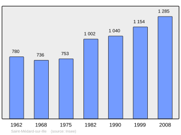
Onderstaande figuur toont het verloop van het inwonertal, bron: INSEE-tellingen.
Bronnen, noten en/of referenties
- ↑ a b Populations légales 2021.
Mediabestanden
Zie de categorie Saint-Médard-sur-Ille van Wikimedia Commons voor mediabestanden over dit onderwerp.


