オクティヴィア・E・バトラー・ランディング

オクティヴィア・E・バトラー・ランディング(英語: Octavia E. Butler Landing)は、2021年2月18日、火星のジェゼロクレーター内のマーズ2020のキュリオシティローバーの着陸地点。2021年3月5日、NASA は、2006年2月24日に亡くなったアメリカで有名なSF作家オクティヴィア・E・バトラーの名前をサイトに付けた[1][2]。火星の着陸地点の座標は、北緯18度26分 東経77度27分 / 北緯18.44度 東経77.45度 / 18.44; 77.45座標: 北緯18度26分 東経77度27分 / 北緯18.44度 東経77.45度 / 18.44; 77.45[3]。
解説

本に署名する作家のオクティヴィア・E・バトラー(2005年)
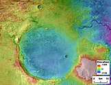
ジェゼロクレーターは、マーズ2020ミッションの一環として、パーサヴィアランスローバーとインジェニュイティヘリコプターの2021年の着陸地点として選ばれた。かつて水が氾濫したと考えられていたクレーターには、粘土が豊富なファンデルタ堆積物が含まれている[4]。クレーターの湖は、火星に谷のネットワークが形成されていたときに存在していた。デルタがあることに加えて、火口はポイントバーと反転したチャネルを示している。デルタと水路の研究から、火口内の湖はおそらく継続的な表面流出があった期間中に形成されたと結論付けられた[5]。湖は長命だったと信じられているので、クレーターで生命が発達したのかも知れません。デルタが形成されるまでに100万年から1000万年の期間が必要だった可能性がある[6]。
オクティヴィア・E・バトラー
オクティヴィア・E・バトラー (1947年6月22日– 2006年2月24日)は、1976年から1998年の間に数多くの小説シリーズを出版したアフリカ系アメリカ人のSF作家。ヒューゴー賞とネビュラ賞の両方を複数回受賞した彼女は、1995年にマッカーサーフェローシップを受賞した最初のSF作家になった[7][8]。
バトラーは、独立した小説、短編小説、エッセイとスピーチを発表した。彼女は、パーサヴィアランスローバープロジェクトを管理するNASAのジェット推進研究所のあるカリフォルニア州パサデナで生まれ育っている。
Octavia E. Butler Landing


インジェニュイティヘリコプターは、空中5.0mから約85m離れたパーサヴィアランスローバー(左)を表示する。(2021年4月25日)

(See also: 火星地図; 火星ローバー地図; 火星記念碑リスト)
( 名称 • 堆積物 • ロスト )

← ビーグル2号

ブラッドベリ・ランディング→
ディープ・スペース2号?→
インサイト着陸地点 →

マルス2号? →
←マルス3号着陸地点
マルス6号? →
ポーラーランダー? ↓

↑「チャレンジャー」メモリアルステーション
↓オクティヴィア・E・バトラー・ランディング
↓ライトブラザーズフィールド
←グリーンバレー

スキアパレッリEDM→

↓カール・セーガン記念ステーション
「コロンビア」メモリアルステーション ↑

トーマス・マッチ記念ステーション→
ジェラルド・ソッフェン記念ステーション→
関連項目
- ブラッドベリ・ランディング
- 地球外の記念碑のリスト
- パーサヴィアランスローバー着陸地点
- マーズ2020のタイムライン(英語版)
- スペキュレイティブ・フィクションの女性(英語版)
脚注
- ^ “NASA's Perseverance Drives on Mars Terrain for First Time”. NASA (2021年3月5日). 2021年3月5日閲覧。
 この記述には、アメリカ合衆国内でパブリックドメインとなっている記述を含む。
 - ^ “Welcome to "Octavia E. Butler Landing"”. NASA. (2021年3月5日). https://mars.nasa.gov/resources/25701/welcome-to-octavia-e-butler-landing/ 2021年3月5日閲覧。 この記述には、アメリカ合衆国内でパブリックドメインとなっている記述を含む。
- ^ “Mars Lander Missions”. NASA Goddard Institute for Space Studies. 2021年10月26日閲覧。
- ^ Muir. “Prime landing sites chosen for biggest Martian rover”. New Scientist. 2018年11月20日閲覧。
- ^ Goudge, T. (2017). Stratigraphy and Evolution of Delta Channel Deposits, Jezero Crater Mars (PDF). Lunar and Planetary Science Conference (2017). 1195.pdf。
- ^ Schon, S.; Head, J.; Fassett, C. (2012). “An overfilled lacustrine system and progradational delta in Jezero crater, Mars: Implications for Noachian climate”. Planetary and Space Science 67 (1): 28–45. Bibcode: 2012P&SS...67...28S. doi:10.1016/j.pss.2012.02.003.
- ^ Crossley, Robert "Critical Essay" In Kindred, by Octavia Butler Boston: Beacon, 2004 ISBN 0807083690 (10) ISBN 978-0807083697 (13)
- ^ “Octavia Butler”. MacArthur Foundation Fellows. 2015年10月9日閲覧。
外部リンク
- マーズ2020とNASAのパーセベランスローバー公式サイト
- Mars 2020: Overview (2:58; 27 July 2020; NASA) - YouTube
- Mars 2020: LANDING of Rover (3:25; 18 February 2021; NASA) - YouTube
| ||||||||||||||||
|---|---|---|---|---|---|---|---|---|---|---|---|---|---|---|---|---|
| 探査 |
|  | ||||||||||||||
| 地理 |
| |||||||||||||||
| 衛星 |
| |||||||||||||||
| 太陽面通過 |
| |||||||||||||||
| 小惑星 | ||||||||||||||||
| 歴史 | ||||||||||||||||
| その他 | ||||||||||||||||
| ||||||||||||||||

| |||||||
|---|---|---|---|---|---|---|---|
| |||||||
| ペイロード |  | ||||||
| ローバー搭載機器 | |||||||
| 特徴 |
| ||||||
| 提案 着陸地点 |
| ||||||
| 関連 |
| ||||||


