Patras
| Patras Πάτρα (Πάτραι) | |
|---|---|
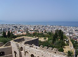 View of Patras from the fortress | |
| Letak | |
  | |
| Koordinat | 38°15′N 21°44′E / 38.250°N 21.733°E / 38.250; 21.733Koordinat: 38°15′N 21°44′E / 38.250°N 21.733°E / 38.250; 21.733 |
| Zona waktu: | EET/EEST (UTC+2/3) |
| Ketinggian (min-max): | 0 - 10 m (0 - 33 ft) |
| Pemerintah | |
| Negara: | Yunani |
| Periferal: | Western Greece |
| Distrik: | 11 |
| Wali kota: | Yannis Dimaras |
| Statistik penduduk (pada 2011[1]) | |
| Kotamadya | |
| - Jumlah penduduk: | 213.984 |
| - Luas: | 333,1 km² (129 sq mi) |
| - Kepadatan: | 642 /km² (1.664 /sq mi) |
| Kode | |
| Kode pos: | 26x xx |
| Kode telepon: | 261 |
| Plat kendaraan: | ΑΧ,AZ |
| Situs web | |
| www | |
 | |
Patras (bahasa Yunani: Πάτρα, pengucapan Yunani: [ˈpatra], Classical Greek dan Katharevousa: Πάτραι (pl.), pengucapan Yunani: [ˈpatre], bahasa Latin: Patrae (pl.)) merupakan kota yang terletak di sebelah selatan Yunani. Penduduknya berjumlah 168.034 jiwa (2011).
Galeri
-
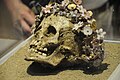 Girl buried with a crown of ceramic flowers (300–400 B.C.), Patras Archaeological Museum
 -
 View of the Roman Odeon
 -
 Athanasios Kanakaris during the Siege of Patras by Peter von Hess
 -
 The port of Patras, 19th century postcard
 -
 The fountain in Georgiou I Square
 -
 View from Agios Nikolaos stairs
 -
 Alhambra mansion
 -
 Catholic Church of Saint Andrew
 -
 Villa Crove at the old English (Egglezika) district of Patras
 -
 The lighthouse


Referensi
- ^ "(875 KB) 2001 Census" (PDF). National Statistical Service of Greece (ΕΣΥΕ) (dalam bahasa Greek). www.statistics.gr. Diakses tanggal 2007-10-30. Pemeliharaan CS1: Bahasa yang tidak diketahui (link)
Wikimedia Commons memiliki media mengenai Patras.
- l
- b
- s


