Västra skogen metro station
Stockholm Metro station
59°20′51″N 18°0′14″E / 59.34750°N 18.00389°E / 59.34750; 18.00389| Preceding station |  Stockholm metro Stockholm metro | Following station | ||
|---|---|---|---|---|
| Stadshagen towards Kungsträdgården | Line 10 | Huvudsta towards Hjulsta | ||
| Line 11 | Solna centrum towards Akalla | |||
Location | |
|---|---|
 |
Västra skogen station | |||||||||||||||||||||||||||||||||||||||||||||||||||||||||||||||||||||||||||||||||||||||||||||||||||||||||||||||||||||||||||||||||||||
|---|---|---|---|---|---|---|---|---|---|---|---|---|---|---|---|---|---|---|---|---|---|---|---|---|---|---|---|---|---|---|---|---|---|---|---|---|---|---|---|---|---|---|---|---|---|---|---|---|---|---|---|---|---|---|---|---|---|---|---|---|---|---|---|---|---|---|---|---|---|---|---|---|---|---|---|---|---|---|---|---|---|---|---|---|---|---|---|---|---|---|---|---|---|---|---|---|---|---|---|---|---|---|---|---|---|---|---|---|---|---|---|---|---|---|---|---|---|---|---|---|---|---|---|---|---|---|---|---|---|---|---|---|---|
Legend | |||||||||||||||||||||||||||||||||||||||||||||||||||||||||||||||||||||||||||||||||||||||||||||||||||||||||||||||||||||||||||||||||||||
| |||||||||||||||||||||||||||||||||||||||||||||||||||||||||||||||||||||||||||||||||||||||||||||||||||||||||||||||||||||||||||||||||||||


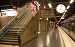
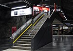
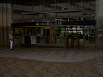
Västra skogen (Swedish: The Western Forest) is a station on the Blue Line of the Stockholm metro, in Huvudsta, Solna Municipality. The station was opened on 31 August 1975 as part the first stretch of the Blue Line between T-Centralen and Hjulsta. The trains were running via Hallonbergen and Rinkeby. On 18 August 1985 the extension to Rinkeby was opened, and the stretch between Hallonbergen and Rinkeby was closed for passenger traffic.[2] It features one of the longest escalators in western Europe, 66 meters and with a vertical rise of 33 meters.[3] This part of Huvudsta was earlier called Ingentingskogen (The Nothing Forest) after a small farm called Ingenting; the name Ingenting (Nothing) was suggested as a name for the new station, but rejected.
The station has three platforms, one for trains towards Hjulsta and Akalla, and two platforms towards Kungsträdgården, to allow trains from the two branches of the line to wait in the station before the two lines merge beyond the station.
Gallery
-
 Entrance
 -
 Platform and train
 -
 Platform stairs
 -
 Entrance detail
 -
 Station's artwork
 -
 Escalators
 -

-
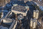 Bird's eye view of the station


References
- ^ "Fakta om SL och regionen 2019" (PDF) (in Swedish). Storstockholms Lokaltrafik. p. 51. Archived (PDF) from the original on 27 December 2020. Retrieved 2 April 2021.
- ^ Schwandl, Robert. "Stockholm". urbanrail.
- ^ Städje, Jörgen (18 October 2009). "Rulltrappor – så funkar de (in Swedish)". IDG News Service. Archived from the original on 4 April 2015. Retrieved 31 March 2015.
External links
- Images of Västra skogen
| |||||||||||||
|---|---|---|---|---|---|---|---|---|---|---|---|---|---|
| Stations |
| ||||||||||||


| Authority control databases: Geographic |
|
|---|
 | This article about a Swedish railway station is a stub. You can help Wikipedia by expanding it. |
- v
- t
- e
 | This Stockholm Metro article is a stub. You can help Wikipedia by expanding it. |
- v
- t
- e


