Turbary Park
Area of West Howe, Bournemouth, Dorset
Turbary Park is an area of West Howe, Bournemouth in Dorset. Turbary Park is south of Kinson and north of Wallisdown.
Geography

Turbary Common is the largest area of heathland in North Bournemouth. It is also a Site of Special Scientific Interest.[1] The habitats include scrub, wooded areas and both wet and dry heath.[2]
Facilities
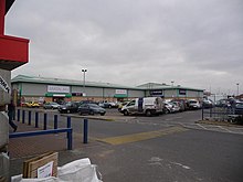
Turbary Park is served by the Turbary Retail Park.[3] Also in the area is the NHS Turbary Park Medical Centre.[4]
Politics
Turbary Park is part of the Bournemouth West constituency. Turbary Park is part of the Kinson ward which elects three councillors to Bournemouth, Christchurch and Poole Council.[5]
References
- ^ "Turbary Common". www.bournemouth.gov.uk. Retrieved 6 October 2020.
- ^ "Turbary Common". Bournemouth. Retrieved 6 October 2020.
- ^ "View Turbary Retail Park, Bournemouth on Completely Retail". completelyretail.co.ukundefined. Retrieved 6 October 2020.
- ^ NHS (28 September 2009). "Contact details - Turbary Park Centre - NHS". www.nhs.uk. Retrieved 6 October 2020.
- ^ "Kinson (Ward, United Kingdom) - Population Statistics, Charts, Map and Location". citypopulation.de. Retrieved 9 May 2021.
- v
- t
- e
Bournemouth, Dorset
- Alder Hills
- Bear Cross
- Boscombe
- Charminster
- East Cliff
- East Howe
- Ensbury Park
- Hengistbury Head
- Hill View
- Holdenhurst
- Iford
- Kings Park
- Kinson
- Knighton Heath
- Lansdowne
- Littledown
- Malmesbury Park
- Mayfield Park Estate
- Meyrick Park
- Moordown
- Muccleshell
- Muscliff
- Northbourne
- Pokesdown
- Queen's Park
- Redhill
- Richmond Hill
- Richmond Park
- Slades Farm
- Southbourne
- Springbourne
- Strouden Park
- Talbot Heath
- Talbot Village
- Talbot Woods
- Throop
- Town Centre
- Townsend
- Tuckton
- Turbary Park
- Victoria Park
- Wallisdown
- Warren Hill
- Westbourne
- West Cliff
- West Howe
- Wick
- Winton
- Withybed Wood
- Woodbury
50°45.1′N 1°55.1′W / 50.7517°N 1.9183°W / 50.7517; -1.9183
 | This Dorset location article is a stub. You can help Wikipedia by expanding it. |
- v
- t
- e


