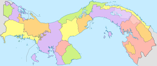
Provinces of Panama
First-level administrative divisions of Panama
| Provinces and Indigenous regions of Panama Provincias y regiones indígenas de Panamá (Spanish) | |
|---|---|
 Bocas del Toro Herrera Los Santos Panamá Oeste Veraguas Guna Yala Naso Tjër Di | |
| Category | Unitary state |
| Location | Republic of Panama |
| Number | 10 provinces (including 2 corregimiento-level indigenous regions) 4 indigenous regions (provincial level) |
| Populations | (Provinces):48,378 (Darién) – 1,410,175 (Panamá) (Indigenous Regions): 10,001 (Emberá-Wounaan) – 156,747 (Ngäbe-Buglé) |
| Areas | (Provinces):2,362.0 km2 (912.0 sq mi) (Herrera) – 11,892.5 km2 (4,591.7 sq mi) (Darién) (Indigenous Regions) 4,393.9 km2 (1,696.5 sq mi) (Emberá-Wounaan) – 6,814.2 km2 (2,631.0 sq mi) (Ngäbe-Buglé) |
| Government |
|
| Subdivisions | |
Panama is divided into ten provinces (Spanish: provincias) and four provincial-level indigenous regions (Spanish: comarcas indígenas, often shortened to comarcas).
There are also two indigenous regions within provinces that are considered equivalent to a corregimiento (municipality).
Provinces
| Province | Capital | Area (km2)[1] | Population (2010 census)[1] | Flag |
|---|---|---|---|---|
| Bocas del Toro | Bocas del Toro | 4,657.2 | 125,461 |  |
| Chiriquí | David | 6,490.9 | 416,873 |  |
| Coclé | Penonomé | 4,949.6 | 233,708 |  |
| Colón | Colón | 4,575.5 | 241,928 |  |
| Darién | La Palma | 11,892.5 | 48,378 |  |
| Herrera | Chitré | 2,362.0 | 109,955 |  |
| Los Santos | Las Tablas | 3,809.4 | 89,592 |  |
| Panamá | Panama City | 8,409.3 | 1,249,032 | |
| Panamá Oeste | La Chorrera | 2,880.1 | 464,038 |  |
| Veraguas | Santiago de Veraguas | 10,587.5 | 226,991 |  |
Indigenous regions (comarcas indígenas)
Provincial level
| Comarca | Capital | Area (km2)[1] | Population (2010 census)[1] | Flag |
|---|---|---|---|---|
| Emberá-Wounaan | Unión Chocó | 4,393.9 | 10,001 | |
| Guna Yala | Gaigirgordub | 2,358.2 | 33,109 |  |
| Ngäbe-Buglé | Llano Tugrí | 6,814.2 | 156,747 |  |
| Naso Tjër Di | Sieyic | 1,606.3 |  |
Corregimiento-level
| Comarca | Province | Area (km2)[1] | Population (2010 census)[1] | Flag |
|---|---|---|---|---|
| Guna de Madungandí | Panamá | 2,075.9 | 4,271 | |
| Guna de Wargandí | Darién | 956.4 | 1,914 |
See also
References
- ^ a b c d e f "Cuadro 11. Superficie, población y densidad de población en la República, según Provincia, Comarca indígena, Distrito y Corregimiento: Censos de 1990, 2000 y 2010". Instituto Nacional de Estadística y Censo, Contraloría General de la República de Panamá. Retrieved 11 November 2016.
- v
- t
- e
Administrative divisions of the Americas
- United States and Canada
- Latin America and the Caribbean
- Latin America
- Hispanic
- North America
- Northern
- Caribbean
- Central America
- South America

- Antigua and Barbuda
- Argentina
- Bahamas
- Barbados
- Belize
- Bolivia
- Brazil
- Canada
- Chile
- Colombia
- Costa Rica
- Cuba
- Dominica
- Dominican Republic
- Ecuador
- El Salvador
- Grenada
- Guatemala
- Guyana
- Haiti
- Honduras
- Jamaica
- Mexico
- Nicaragua
- Panama
- Paraguay
- Peru
- Saint Kitts and Nevis
- Saint Lucia
- Saint Vincent and the Grenadines
- Suriname
- Trinidad and Tobago
- United States
- Uruguay
- Venezuela
- Anguilla
- Aruba
- Bermuda
- Bonaire
- British Virgin Islands
- Cayman Islands
- Curaçao
- Falkland Islands
- French Guiana
- Greenland
- Guadeloupe
- Martinique
- Montserrat
- Puerto Rico
- Saba
- Saint Barthélemy
- Saint Martin
- Saint Pierre and Miquelon
- Sint Eustatius
- Sint Maarten
- South Georgia and the South Sandwich Islands
- Turks and Caicos Islands
- U.S. Virgin Islands
Provinces and comarcas of Panama | ||
|---|---|---|
| Provinces |
| |
Corregimiento-level Comarcas indígenas | ||


