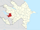
Otaqlı
40°07′18″N 46°01′01″E / 40.12167°N 46.01694°E / 40.12167; 46.01694


 Azerbaijan
Otaqlı (Otagly) is a ghost village in the Kalbajar District of Azerbaijan.
History
The village was located in the Armenian-occupied territories surrounding Nagorno-Karabakh, coming under the control of ethnic Armenian forces during the First Nagorno-Karabakh War in the early 1990s.
The village subsequently became part of the self-proclaimed Republic of Artsakh as part of its Kashatagh Province.
It was returned to Azerbaijan as part of the 2020 Nagorno-Karabakh ceasefire agreement. Subsequently, Azerbaijani Ministry of Defence published a video from the village, showing the ruined state of the village following its occupation.[1]
References
- ^ Otaqli ghost village shown in a video made shortly after the area's return to Azerbaijani rule in 2020
- Otaqlı at GEOnet Names Server
- v
- t
- e
- Abdullauşağı
- Ağbulaq
- Ağcakənd
- Ağdaban
- Ağdaş
- Ağqaya
- Ağyataq
- Alçalı
- Alıbəyli
- Alırzalar
- Allıkənd
- Almalıq
- Alolar
- Armudlu
- Aşağı Ayrım
- Aşağı Şurtan
- Aşağı Qaraçanlı
- Babaşlar
- Bağırlı
- Bağırsaq
- Bağlıpəyə
- Barmaqbinə
- Başkənd
- Başlıbel
- Baş Qaraçanlı
- Bazarkənd
- Bəzirxana
- Birinci Milli
- Boyaqlı
- Bozlu
- Böyükdüz
- Böyürbinə
- Cəmilli
- Comərd
- Çaykənd
- Çayqovuşan
- Çəpli
- Çərəktar
- Çıldıran
- Çıraq
- Çobankərəhməz
- Çopurlu
- Çorman
- Çormanlı
- Çovdar
- Dalqılınclı
- Damğalı
- Daşbulaq
- Dəmirçidam
- Dərəqışlaq
- Dəvədaşı
- Dovşanlı
- Əsrik
- Fətallar
- Göydərə
- Güneypəyə
- Günəşli
- Günəşqaya
- Hacıdünyamalılar
- Hacıkənd
- Hayad
- Heyvalı
- Həsənlər
- Həsənriz
- Hopurlu
- İkinci Milli
- İlyaslar
- İmanbinəsi
- İstibulaq
- İstisu
- Kaha
- Keçiliqaya
- Keşdək
- Kəndyeri
- Kərəmli
- Kolatağ
- Laçın
- Lev
- Mehmana
- Məmmədsəfi
- Məmməduşağı
- Mərcimək
- Mişni
- Mollabayramlı
- Moz
- Mozqaraçanlı
- Nadirxanlı
- Narınclar
- Nəbilər
- Nəcafalı
- Orta Qaraçanlı
- Orta Şurtan
- Oruclu
- Otaqlı
- Otqışlaq
- Pirilər
- Qalaboyun
- Qamışlı
- Qanlıkənd
- Qaragüney
- Qaraxançallı
- Qasımbinəsi
- Qasımlar
- Qazıxanlı
- Qılınclı
- Qızılqaya
- Qozlu
- Qozlukörpü
- Quzeyçirkin
- Rəhimli
- Sarıdaş
- Seyidlər
- Soyuqbulaq
- Susuzluq
- Şahkərəm
- Şahmansurlu
- Şaplar
- Şeyinli
- Tağılar
- Tatlar
- Taxtabaşı
- Təkdam
- Təkəqaya
- Təzəkənd
- Tirkeşəvənd
- Tövlədərə
- Üçüncü Milli
- Vəng
- Vəngli
- Xallanlı
- Xoləzəy
- Yanşaq
- Yanşaqbinə
- Yayıcı
- Yellicə
- Yenikənd
- Yuxarı Ayrım
- Yuxarı Oratağ
- Yuxarı Şurtan
- Zağalar
- Zallar
- Zar
- Zərqulu
- Zəylik
- Zivel
- Zülfüqarlı

 | This Kalbajar Rayon location article is a stub. You can help Wikipedia by expanding it. |
- v
- t
- e


