National Register of Historic Places listings in Ouachita County, Arkansas

This is a list of the National Register of Historic Places listings in Ouachita County, Arkansas.
This is intended to be a complete list of the properties and districts on the National Register of Historic Places in Ouachita County, Arkansas, United States. The locations of National Register properties and districts for which the latitude and longitude coordinates are included below, may be seen in a map.[1]
There are 41 properties and districts listed on the National Register in the county, including 3 distinct parts of one discontiguous National Historic Landmark District.
This National Park Service list is complete through NPS recent listings posted June 21, 2024.[2]
Map all coordinates using OpenStreetMap
Download coordinates as:
- KML
- GPX (all coordinates)
- GPX (primary coordinates)
- GPX (secondary coordinates)
Current listings
| [3] | Name on the Register[4] | Image | Date listed[5] | Location | City or town | Description |
|---|---|---|---|---|---|---|
| 1 | Arkansas Highway 57 Bridge |  | September 28, 2005 (#05001078) | Formerly carried Highway 57 over a Union Pacific railroad line 33°24′46″N 93°04′10″W / 33.412778°N 93.069444°W / 33.412778; -93.069444 (Arkansas Highway 57 Bridge) | Stephens | |
| 2 | Bearden Waterworks |  | October 5, 2006 (#06000908) | Junction of N. 2nd and N. Cedar 33°43′39″N 92°37′01″W / 33.7275°N 92.616944°W / 33.7275; -92.616944 (Bearden Waterworks) | Bearden | |
| 3 | Bragg House |  | March 1, 1974 (#74000487) | West of Camden on Highway 4 33°34′52″N 92°53′56″W / 33.581111°N 92.898889°W / 33.581111; -92.898889 (Bragg House) | Camden | |
| 4 | Capt. John T. Burkett House |  | June 3, 1998 (#98000620) | 607 County Road 65 33°26′27″N 92°47′39″W / 33.440833°N 92.794167°W / 33.440833; -92.794167 (Capt. John T. Burkett House) | Frenchport | |
| 5 | Camden Commercial Historic District | Upload image | November 2, 2022 (#100008151) | Roughly Washington St. between Harrison and Madison Sts., and Adams Ave. between Washington and Jefferson Sts. 33°35′10″N 92°49′47″W / 33.5861°N 92.8297°W / 33.5861; -92.8297 (Camden Commercial Historic District) | Camden | |
| 6 | Camden Confederate Monument |  | May 7, 1996 (#96000462) | Courthouse Lawn, Jefferson St. between Harrison St. and Scott Alley 33°35′03″N 92°49′49″W / 33.584167°N 92.830278°W / 33.584167; -92.830278 (Camden Confederate Monument) | Camden | |
| 7 | Camden Water Battery | Upload image | May 30, 2007 (#07000615) | Address Restricted | Camden | Civil War fortifications along the riverfront |
| 8 | Clifton and Greening Streets Historic District |  | August 14, 1998 (#98000911) | Roughly bounded by Clifton and Greening Sts., and Dallas and Cleveland Aves. Boundary increase I (listed November 19, 2001): 411 and 417 Greening St. Boundary increase II (listed September 19, 2007): 622, 630, and 634 Clifton St., 206 Dallas Ave., and 502 Greening St. Boundary increase III (listed September 23, 2011): 140 California St. 33°35′13″N 92°50′10″W / 33.5869°N 92.8361°W / 33.5869; -92.8361 (Clifton and Greening Streets Historic District) | Camden | |
| 9 | Elliott-Meek House |  | March 1, 1974 (#74000483) | 761 Washington St. 33°35′02″N 92°50′30″W / 33.583889°N 92.841667°W / 33.583889; -92.841667 (Elliott-Meek House) | Camden | |
| 10 | Fort Lookout |  | April 19, 1994 (#94001183) | Southern bank of the Ouachita River, about 1.0 mile west of U.S. Highway 79 33°36′00″N 92°50′04″W / 33.6°N 92.834444°W / 33.6; -92.834444 (Fort Lookout) | Camden | One of the Camden Expedition Sites, a National Historic Landmark consisting of sites in several counties |
| 11 | Fort Southerland | 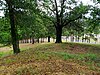 | April 19, 1994 (#94001184) | Roughly bounded by Lear Ave., Bradley Ferry Rd., and Progress St. 33°34′25″N 92°49′03″W / 33.573611°N 92.8175°W / 33.573611; -92.8175 (Fort Southerland) | Camden | One of the Camden Expedition Sites, a National Historic Landmark consisting of sites in several counties |
| 12 | Graham-Gaughan-Betts House |  | October 18, 1974 (#74000484) | 710 Washington St. 33°35′05″N 92°50′24″W / 33.584722°N 92.84°W / 33.584722; -92.84 (Graham-Gaughan-Betts House) | Camden | |
| 13 | Green Cemetery | Upload image | May 5, 2017 (#16000653) | West of County Road 1 33°25′56″N 93°05′55″W / 33.432222°N 93.098611°W / 33.432222; -93.098611 (Green Cemetery) | Stephens | |
| 14 | Harvey's Grocery and Texaco Station |  | May 25, 2001 (#01000524) | 3241 Highway 24 33°36′31″N 92°54′43″W / 33.608611°N 92.911944°W / 33.608611; -92.911944 (Harvey's Grocery and Texaco Station) | Camden | |
| 15 | Hickman House |  | March 2, 2006 (#06000090) | 3568 Mt. Holly Rd. 33°30′29″N 92°51′09″W / 33.507947°N 92.852517°W / 33.507947; -92.852517 (Hickman House) | Camden | |
| 16 | Holt-Poindexter Store Building |  | October 23, 1986 (#86002948) | County Road 33°27′08″N 93°01′24″W / 33.452222°N 93.023333°W / 33.452222; -93.023333 (Holt-Poindexter Store Building) | Stephens | |
| 17 | The HOMER (Shipwreck) | Upload image | September 14, 2002 (#02000979) | Address Restricted | Camden | Paddlewheel steamer scuttled during the Civil War |
| 18 | Ben Laney Bridge |  | June 9, 2000 (#00000633) | U.S. Highway 79B over the Ouachita River 33°35′47″N 92°49′07″W / 33.596389°N 92.818611°W / 33.596389; -92.818611 (Ben Laney Bridge) | Camden | |
| 19 | Leake-Ingham Building |  | May 2, 1975 (#75000399) | 926 Washington St., NW. 33°35′05″N 92°50′38″W / 33.584722°N 92.843889°W / 33.584722; -92.843889 (Leake-Ingham Building) | Camden | Law office building, now a museum building behind the McCollum-Chidester House |
| 20 | Lester And Haltom No. 1 Well Site | Upload image | April 3, 1976 (#76000442) | Northeast of Stephens on Old Wire Rd. (County Road 3) 33°25′43″N 93°00′45″W / 33.428611°N 93.0125°W / 33.428611; -93.0125 (Lester And Haltom No. 1 Well Site) | Stephens | Site of the first oil discovery in Arkansas |
| 21 | McCollum-Chidester House |  | June 24, 1971 (#71000127) | 926 Washington St., NW. 33°35′05″N 92°50′32″W / 33.584722°N 92.842222°W / 33.584722; -92.842222 (McCollum-Chidester House) | Camden | Ouachita County Historical Society museum |
| 22 | Missouri Pacific Railroad Depot-Camden |  | June 11, 1992 (#92000605) | Southwestern corner of the junction of Main and 1st Sts. 33°34′56″N 92°49′40″W / 33.582222°N 92.827778°W / 33.582222; -92.827778 (Missouri Pacific Railroad Depot-Camden) | Camden | |
| 23 | Oakland Cemetery |  | June 9, 2000 (#00000634) | 100 block of Maul Rd., bounded by Pearl St. and Madison Ave. 33°35′36″N 92°49′59″W / 33.593333°N 92.833056°W / 33.593333; -92.833056 (Oakland Cemetery) | Camden | |
| 24 | Oakland Farm |  | March 24, 1978 (#78003062) | South of Camden at Tate and Oakland Sts. 33°32′32″N 92°50′50″W / 33.542222°N 92.847222°W / 33.542222; -92.847222 (Oakland Farm) | Camden | |
| 25 | Old Camden Post Office |  | May 2, 1977 (#77000263) | 133 Washington St., SW. 33°35′09″N 92°49′49″W / 33.585833°N 92.830278°W / 33.585833; -92.830278 (Old Camden Post Office) | Camden | 1895 brick post office |
| 26 | Ouachita County Courthouse |  | November 13, 1989 (#89001958) | 145 Jefferson Ave. 33°35′04″N 92°49′49″W / 33.584444°N 92.830278°W / 33.584444; -92.830278 (Ouachita County Courthouse) | Camden | |
| 27 | Ouachita County Training School | Upload image | September 12, 2023 (#100009343) | 740 Ouachita Rd. 589 33°43′59″N 92°36′17″W / 33.7331°N 92.6046°W / 33.7331; -92.6046 (Ouachita County Training School) | Bearden | |
| 28 | Poison Spring State Park |  | December 3, 1969 (#69000036) | Northwest of Camden 33°38′45″N 93°01′02″W / 33.645833°N 93.017222°W / 33.645833; -93.017222 (Poison Spring State Park) | Chidester | |
| 29 | Benjamin T. Powell House | 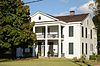 | January 21, 1974 (#74000485) | 305 California Ave. 33°34′52″N 92°49′59″W / 33.581111°N 92.833056°W / 33.581111; -92.833056 (Benjamin T. Powell House) | Camden | |
| 30 | Richmond-Tufts House |  | December 2, 1977 (#77000264) | Northwest of Camden on Highway 24 33°36′25″N 92°54′31″W / 33.606944°N 92.908611°W / 33.606944; -92.908611 (Richmond-Tufts House) | Camden | |
| 31 | Rumph House |  | September 25, 2003 (#03000948) | 717 Washington St. 33°35′03″N 92°50′25″W / 33.584167°N 92.840278°W / 33.584167; -92.840278 (Rumph House) | Camden | |
| 32 | St. John's Episcopal Church |  | January 24, 2017 (#100000556) | 117 Harrison St. 33°35′10″N 92°49′54″W / 33.586120°N 92.831562°W / 33.586120; -92.831562 (St. John's Episcopal Church) | Camden | |
| 33 | Rowland B. Smith House |  | January 21, 1974 (#74000486) | 234 Agee St. 33°34′54″N 92°50′38″W / 33.581667°N 92.843889°W / 33.581667; -92.843889 (Rowland B. Smith House) | Camden | |
| 34 | Spring-Harrison Historic District | Upload image | January 11, 2021 (#100006026) | Spring St. roughly between Greening and Thompson Sts.' Clifton St. roughly between Spring and Harrison Sts., and Harrison St. roughly between Van Buren and Clifton Sts. 33°35′13″N 92°49′58″W / 33.5869°N 92.8327°W / 33.5869; -92.8327 (Spring-Harrison Historic District) | Camden | |
| 35 | Standard Oil Company Oil Station Pumphouse | Upload image | September 16, 2022 (#100008150) | 505 East Washington St. 33°35′21″N 92°49′29″W / 33.5892°N 92.8247°W / 33.5892; -92.8247 (Standard Oil Company Oil Station Pumphouse) | Camden | |
| 36 | Tate's Barn |  | November 9, 1972 (#72000207) | 902 Tate St. 33°32′30″N 92°50′41″W / 33.541667°N 92.844722°W / 33.541667; -92.844722 (Tate's Barn) | Camden | |
| 37 | Tate's Bluff Fortification | Upload image | December 31, 2002 (#02001628) | Address Restricted | Tate's Bluff | |
| 38 | Two Bayou Methodist Church and Cemetery |  | July 9, 1998 (#98000830) | County Road 125 33°32′42″N 92°57′44″W / 33.545°N 92.962222°W / 33.545; -92.962222 (Two Bayou Methodist Church and Cemetery) | Camden | |
| 39 | Tyson Family Commercial Building |  | November 21, 1994 (#94001339) | 151 Adams St., SE. 33°35′04″N 92°49′45″W / 33.584444°N 92.829167°W / 33.584444; -92.829167 (Tyson Family Commercial Building) | Camden | |
| 40 | Sidney A. Umsted House |  | June 30, 1995 (#95000789) | 404 Washington St. 33°35′06″N 92°50′04″W / 33.585°N 92.834444°W / 33.585; -92.834444 (Sidney A. Umsted House) | Camden | |
| 41 | Washington Street Historic District |  | January 22, 2010 (#09001256) | 404-926 W. Washington, 619-816 Graham, 116-132 N. Cleveland, 131-139 N. Agee and 132 N. California; also N & S Agee St. roughly between Clifton & Maple Sts. 33°35′05″N 92°50′17″W / 33.584597°N 92.837956°W / 33.584597; -92.837956 (Washington Street Historic District) | Camden | Second set of addresses represent a boundary increase approved May 21, 2018. |
See also
Wikimedia Commons has media related to National Register of Historic Places in Ouachita County, Arkansas.
- List of National Historic Landmarks in Arkansas
- National Register of Historic Places listings in Arkansas
References
- ^ The latitude and longitude information provided in this table was derived originally from the National Register Information System, which has been found to be fairly accurate for about 99% of listings. Some locations in this table may have been corrected to current GPS standards.
- ^ National Park Service, United States Department of the Interior, "National Register of Historic Places: Weekly List Actions", retrieved June 21, 2024.
- ^ Numbers represent an alphabetical ordering by significant words. Various colorings, defined here, differentiate National Historic Landmarks and historic districts from other NRHP buildings, structures, sites or objects.
- ^ "National Register Information System". National Register of Historic Places. National Park Service. March 13, 2009.
- ^ The eight-digit number below each date is the number assigned to each location in the National Register Information System database, which can be viewed by clicking the number.
- v
- t
- e
- List of U.S. National Historic Landmarks by state:
- Alabama
- Alaska
- Arizona
- Arkansas
- California
- Colorado
- Connecticut
- Delaware
- Florida
- Georgia
- Hawaii
- Idaho
- Illinois
- Indiana
- Iowa
- Kansas
- Kentucky
- Louisiana
- Maine
- Maryland
- Massachusetts
- Michigan
- Minnesota
- Mississippi
- Missouri
- Montana
- Nebraska
- Nevada
- New Hampshire
- New Jersey
- New Mexico
- New York
- North Carolina
- North Dakota
- Ohio
- Oklahoma
- Oregon
- Pennsylvania
- Rhode Island
- South Carolina
- South Dakota
- Tennessee
- Texas
- Utah
- Vermont
- Virginia
- Washington
- West Virginia
- Wisconsin
- Wyoming
 National Register of Historic Places portal
 Category


Municipalities and communities of Ouachita County, Arkansas, United States | ||
|---|---|---|
County seat: Camden | ||
| Cities | 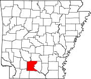 | |
| Town | ||
| CDP | ||
| Other unincorporated communities | ||
| Footnotes | ‡This populated place also has portions in an adjacent county or counties | |
| ||


