National Register of Historic Places listings in Morrill County, Nebraska
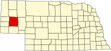
This is a list of the National Register of Historic Places listings in Morrill County, Nebraska.
This is intended to be a complete list of the properties and districts on the National Register of Historic Places in Morrill County, Nebraska, United States. The locations of National Register properties and districts for which the latitude and longitude coordinates are included below may be seen in a map.[1]
There are 8 properties and districts listed on the National Register in the county.
This National Park Service list is complete through NPS recent listings posted June 21, 2024.[2]
Map all coordinates using OpenStreetMap
Download coordinates as:
- KML
- GPX (all coordinates)
- GPX (primary coordinates)
- GPX (secondary coordinates)
Current listings
| [3] | Name on the Register[4] | Image | Date listed[5] | Location | City or town | Description |
|---|---|---|---|---|---|---|
| 1 | Camp Clarke Bridge Site |  | November 8, 1974 (#74001129) | West of Bridgeport 41°41′24″N 103°10′43″W / 41.69°N 103.178611°W / 41.69; -103.178611 (Camp Clarke Bridge Site) | Bridgeport | Site of a wooden toll bridge built in 1875 to serve the Dakota gold fields. |
| 2 | Chimney Rock National Historic Site | 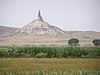 | October 15, 1966 (#66000116) | 3 miles (4.8 km) southwest of Bayard 41°42′09″N 103°20′49″W / 41.7025°N 103.346944°W / 41.7025; -103.346944 (Chimney Rock National Historic Site) | Bayard | |
| 3 | Courthouse and Jail House Rocks | 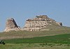 | April 24, 1973 (#73001067) | 5 miles (8.0 km) south of Bridgeport 41°36′02″N 103°07′00″W / 41.600556°N 103.116667°W / 41.600556; -103.116667 (Courthouse and Jail House Rocks) | Bridgeport | |
| 4 | Greenwood Stage Station | Upload image | March 13, 2012 (#12000106) | Appr. location 41°30′07″N 103°04′57″W / 41.501994°N 103.0825°W / 41.501994; -103.0825 (Greenwood Stage Station) | Bridgeport | |
| 5 | Morrill County Courthouse |  | January 10, 1990 (#89002227) | Main St. between 6th and 7th Sts. 41°40′07″N 103°06′00″W / 41.66864°N 103.10006°W / 41.66864; -103.10006 (Morrill County Courthouse) | Bridgeport | |
| 6 | Mud Springs Station Archeological District | 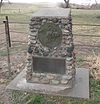 | April 24, 1973 (#73001068) | County road 107 between 68 and 70[6] 41°29′04″N 103°01′02″W / 41.4845°N 103.01712°W / 41.4845; -103.01712 (Mud Springs Station Archeological District) | Dalton | Originally listed as "Mud Springs Pony Express Station Site"; boundaries increased on September 6, 2011[4] |
| 7 | Rush Creek Battlefield |  | September 6, 2011 (#11000619) | Southern side of the Platte River at the mouth of Rush Creek[7] 41°33′05″N 102°48′45″W / 41.551389°N 102.812500°W / 41.551389; -102.812500 (Rush Creek Battlefield) | Broadwater | |
| 8 | Schuetz Log Cabin | 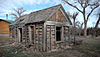 | March 21, 2011 (#11000105) | HC 82 Box 103 41°29′57″N 103°05′17″W / 41.499167°N 103.088056°W / 41.499167; -103.088056 (Schuetz Log Cabin) | Dalton | A settler family's log cabin, built during 1900-20. |
See also
Wikimedia Commons has media related to National Register of Historic Places in Morrill County, Nebraska.
- List of National Historic Landmarks in Nebraska
- National Register of Historic Places listings in Nebraska
References
- ^ The latitude and longitude information provided in this table was derived originally from the National Register Information System, which has been found to be fairly accurate for about 99% of listings. Some locations in this table may have been corrected to current GPS standards.
- ^ National Park Service, United States Department of the Interior, "National Register of Historic Places: Weekly List Actions", retrieved June 21, 2024.
- ^ Numbers represent an alphabetical ordering by significant words. Various colorings, defined here, differentiate National Historic Landmarks and historic districts from other NRHP buildings, structures, sites or objects.
- ^ a b "National Register Information System". National Register of Historic Places. National Park Service. July 9, 2010.
- ^ The eight-digit number below each date is the number assigned to each location in the National Register Information System database, which can be viewed by clicking the number.
- ^ Driving directions to Mud Springs are at "Mud Springs Pony Express Station Site", National Park Service, retrieved 2013-04-25. The site is marked as "Pony Express Marker" on the Morrill County S map, Nebraska Department of Roads, retrieved 2013-04-25.
- ^ "Fort Laramie National Historic Site Hosts Program on Mud Spring and Rush Creek Battles". Gering Citizen 2011-07-14. Accessed 2013-04-18.
- v
- t
- e

- Adams
- Antelope
- Arthur
- Banner
- Blaine
- Boone
- Box Butte
- Boyd
- Brown
- Buffalo
- Burt
- Butler
- Cass
- Cedar
- Chase
- Cherry
- Cheyenne
- Clay
- Colfax
- Cuming
- Custer
- Dakota
- Dawes
- Dawson
- Deuel
- Dixon
- Dodge
- Douglas
- Dundy
- Fillmore
- Franklin
- Frontier
- Furnas
- Gage
- Garden
- Garfield
- Gosper
- Grant
- Greeley
- Hall
- Hamilton
- Harlan
- Hayes
- Hitchcock
- Holt
- Hooker
- Howard
- Jefferson
- Johnson
- Kearney
- Keith
- Keya Paha
- Kimball
- Knox
- Lancaster
- Lincoln
- Logan
- Loup
- Madison
- McPherson
- Merrick
- Morrill
- Nance
- Nemaha
- Nuckolls
- Otoe
- Pawnee
- Perkins
- Phelps
- Pierce
- Platte
- Polk
- Red Willow
- Richardson
- Rock
- Saline
- Sarpy
- Saunders
- Scotts Bluff
- Seward
- Sheridan
- Sherman
- Sioux
- Stanton
- Thayer
- Thomas
- Thurston
- Valley
- Washington
- Wayne
- Webster
- Wheeler
- York
- Bridges
- Historic districts
- Houses
- National Historic Landmarks
- Properties of religious function
- Railway stations
 Category
 List
List National Register of Historic Places Portal


Municipalities and communities of Morrill County, Nebraska, United States | ||
|---|---|---|
County seat: Bridgeport | ||
| Cities |  | |
| Village | ||
| Unincorporated communities | ||
| ||


