Mount Tlingit
Mountain summit in Alaska, US


Mount Tlingit
Location of Mount Tlingit in Alaska
Alaska, United States
Saint Elias Mountains
Mount Tlingit is a 12,606-foot (3,842-meter) mountain summit in Alaska, United States.
Description
Mount Tlingit is part of the Fairweather Range which is a subrange of the Saint Elias Mountains. The glaciated peak is located in Glacier Bay National Park, 2.3 mi (4 km) southeast of the Canada–United States border, and 4.8 mi (8 km) east of Mount Fairweather, which is the highest peak in the Fairweather Range.[1] Tlingit ranks as the sixth-highest peak in the park and 76th-highest in Alaska.[2] Precipitation runoff and meltwater from its surrounding glaciers drains into Glacier Bay Basin and the Gulf of Alaska. The mountain's toponym has not been officially adopted by the United States Board on Geographic Names. Mount Tlingit should not be confused with officially-named Tlingit Peak (3,169 feet) which is also within Glacier Bay National Park.[3]
Climate
Based on the Köppen climate classification, Mount Tlingit has a subarctic climate with cold, snowy winters, and cool summers.[4] Winter temperatures can drop below −20 °C with wind chill factors below −30 °C. This climate supports the Margerie Glacier to the east of the summit and Fairweather Glacier to the southwest. The months May through June offer the most favorable weather for viewing or climbing.
See also
 Mountains portal
- Geography of Alaska

Gallery
-
 Mt. Tlingit
 -
 Mount Tlingit to the left
 -
 Aerial view of Mt. Salisbury (center) and Mt. Tlingit (right)
 -
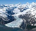 Aerial view of Marjorie Glacier with Mt. Salisbury, Mt. Tlingit, and Mt. Quincy Adams across the top of frame.
 -
 Mt. Tlingit (left) with Mt. Quincy Adams behind
 -
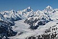
 Mount Fairweather centered with Mount Tlingit to right
 -
 Aerial view of Mount Tlingit (left) with Mt. Quincy Adams and Mount Fairweather at the top.


References
- ^ a b c d "Mount Tlingit, Alaska". Peakbagger.com. Retrieved 2023-11-17.
- ^ a b c d e "Mount Tlingit - 12,606' AK". listsofjohn.com. Retrieved 2023-11-17.
- ^ "Tlingit Peak". Geographic Names Information System. United States Geological Survey, United States Department of the Interior. Retrieved 2023-11-17.
- ^ Peel, M. C.; Finlayson, B. L.; McMahon, T. A. (2007). "Updated world map of the Köppen−Geiger climate classification". Hydrol. Earth Syst. Sci. 11. ISSN 1027-5606.
External links
- Glacier Bay National Park and Preserve – National Park Service site
Places adjacent to Mount Tlingit | ||||||||||||||||
|---|---|---|---|---|---|---|---|---|---|---|---|---|---|---|---|---|
| ||||||||||||||||


