Mount Stratus
Mountain in the state of Colorado


Mount Stratus
Location in Colorado
Show map of Colorado
Mount Stratus
Mount Stratus (the United States)
Show map of the United StatesNever Summer Wilderness
Never Summer Mountains
Mount Stratus is a 12,534-foot-elevation (3,820-meter) mountain summit in Grand County, Colorado, United States.
Description
Mount Stratus is the ninth-highest peak of the Never Summer Mountains which are a subrange of the Rocky Mountains.[6] The mountain is situated on the western boundary of Rocky Mountain National Park and is visible from Trail Ridge Road within the park. The west side of the peak is in the Never Summer Wilderness which is managed by Arapaho National Forest. Precipitation runoff from the mountain's slopes drains into tributaries of the Colorado River except for a portion which is diverted by the Grand Ditch. Topographic relief is significant as the summit rises 3,600 feet (1,100 meters) above the Kawuneeche Valley in 2.5 miles (4.0 km) and 1,700 feet (520 meters) above Baker Gulch in three-quarters of a mile. An ascent of the peak involves hiking 12.8 miles (20.6 km) round-trip with 3,555 feet (1,084 m) of elevation gain.[7]
Etymology
The mountain's toponym has been officially adopted by the United States Board on Geographic Names.[2][8] In 1914, James Grafton Rogers named Mount Cirrus, Mount Nimbus, and Mount Cumulus for different types of common clouds, but he did not name Mt. Stratus, it was added later.[9]
Climate
According to the Köppen climate classification system, Mount Nimbus is located in an alpine subarctic climate zone with cold, snowy winters, and cool to warm summers.[10] Due to its altitude, it receives precipitation all year, as snow in winter, and as thunderstorms in summer, with a dry period in late spring.
See also
- List of peaks in Rocky Mountain National Park
- Mountains of Grand County, Colorado
 Mountains portal

Gallery
-
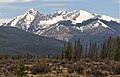 Baker Mountain (left), Mount Stratus (center), Green Knoll (right)
 -
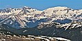 Mt. Stratus (left), Mt. Nimbus, and Mt. Cumulus (right)
 -
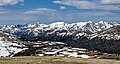 Never Summer Mountains viewed from Trail Ridge Road. Left to rightːMt. Stratus, Mt. Nimbus, Mt. Cumulus (centered), Howard Mountain, Mt. Cirrus


References
- ^ a b c d "Stratus, Mount - 12,534' CO". listsofjohn.com. Retrieved May 8, 2023.
- ^ a b "Mount Stratus". Geographic Names Information System. United States Geological Survey, United States Department of the Interior. Retrieved May 8, 2023.
- ^ "Mount Stratus, Colorado". Peakbagger.com. Retrieved May 8, 2023.
- ^ Geologic map of the Mount Richthofen quadrangle and the western part of the Fall River Pass quadrangle, Grand and Jackson Counties, Colorado, J.M. O'Neill, U.S. Geological Survey, 1981.
- ^ Lisa Foster (2005), Rocky Mountain National Park: The Complete Hiking Guide, Westcliffe Publishers, ISBN 9781565795501, p. 343.
- ^ "Mount Stratus, Peakvisor.com". Retrieved May 8, 2023.
- ^ Alan Apt, Kay Turnbaugh (2015), Afoot and Afield: Denver, Boulder, Fort Collins, and Rocky Mountain National Park, Wilderness Press, ISBN 9780899977553, p. 230.
- ^ Decisions of the United States Geographic Board No. 27, (June 30, 1932), US Government Printing Office, p. 6.
- ^ James Dziezynski (2012), Best Summit Hikes in Colorado, AdventureKEEN, ISBN 9780899977126, p. 82.
- ^ Peel, M. C.; Finlayson, B. L.; McMahon, T. A. (2007). "Updated world map of the Köppen−Geiger climate classification". Hydrol. Earth Syst. Sci. 11. ISSN 1027-5606.
External links
- Weather forecast: Mount Stratus
Places adjacent to Mount Stratus | ||||||||||||||||
|---|---|---|---|---|---|---|---|---|---|---|---|---|---|---|---|---|
| ||||||||||||||||


- v
- t
- e

- Mount Garfield
- Aspen Mountain
- Capitol Peak
- Castle Peak
- Cathedral Peak
- Chair Mountain
- Crested Butte
- Gothic Mountain
- Italian Mountain
- Maroon Bells
- Mount Emmons
- Mount Owen
- Mount Sopris
- Pyramid Peak
- Snowmass Mountain
- Snowmass Peak
- Treasure Mountain
- Black Mountain (Moffat County)
- Columbus Mountain
- Elk Mountain (Routt County)
- Hahns Peak
- Flat Top Mountain
- Sleepy Cat Peak
- Eagles Nest
- Jacque Peak
- Meridian Peak
- Mount Powell
- The Spider
- Crater Peak
- North Mamm Peak
- Clark Peak
- Arkansas Hills
- Clinton Peak
- Dyer Mountain
- Gemini Peak
- Horseshoe Mountain
- Mount Arkansas
- Mount Bross
- Mount Buckskin
- Mount Democrat
- Mount Lincoln
- Mount Sheridan
- Mount Sherman
- Pacific Peak
- West Buffalo Peak
- Elk Mountain (Grand County)
- Parkview Mountain
- Radial Mountain
- Whiteley Peak
| Sangre de Cristo Range |
|
|---|---|
| Wet Mountains |
|
| Others |
|
| Collegiate Peaks |
|
|---|---|
| Others |
|
- Crystal Peak
- Fletcher Mountain
- Peak 10
- Peak One
- Quandary Peak
- Tenmile Peak
- Bear Mountain
- Blair Mountain
- Chalk Mountains
- Cochetopa Hills
- Dawson Butte
- Diamond Peak
- Flirtation Peak
- Granite Peak
- Grand Hogback
- Grannys Nipple
- Horsefly Peak
- Lead Mountain (Grand County)
- Mount Neva
- Powell Peak
- San Luis Hills
- Storm King Mountain
- Terrible Mountain
- Two Buttes
- Ute Mountain


