List of crossings of the Kootenay River
This is a list of bridges and other crossings of the Kootenay River from its source downstream to the Columbia River.
Crossings
| Crossing | Carries | Location | Coordinates | Image | |
|---|---|---|---|---|---|
| Kootenay Crossing Bridge |  Hwy 93 Hwy 93 | Kootenay Crossing, British Columbia (Kootenay National Park) | 50°53′13″N 116°02′44″W / 50.8869°N 116.0455°W / 50.8869; -116.0455 | ||
| Canal Flats Bridge |  Hwy 93 / Hwy 95 Hwy 93 / Hwy 95 | Canal Flats, British Columbia | 50°08′52″N 115°48′03″W / 50.1479°N 115.8009°W / 50.1479; -115.8009 | ||
| Springbrook Bridge | Hwy 93 / Hwy 95 | Skookumchuck, British Columbia | 49°54′39″N 115°44′14″W / 49.9108°N 115.7372°W / 49.9108; -115.7372 | ||
| Wasa Bridge | Hwy 93 / Hwy 95 | Near Wasa, British Columbia | 49°48′34″N 115°46′02″W / 49.8094°N 115.7671°W / 49.8094; -115.7671 | ||
| Fort Steele Bridge | Hwy 93 / Hwy 95 | Fort Steele, British Columbia | 49°36′45″N 115°38′04″W / 49.6125°N 115.6345°W / 49.6125; -115.6345 | ||
| Wardner Bridge |  Hwy 3 / Hwy 93 Hwy 3 / Hwy 93 | Near Wardner, British Columbia | 49°26′00″N 115°25′21″W / 49.4333°N 115.4224°W / 49.4333; -115.4224 | ||
| Highway Bridge | Kikomun-Newgate Road | near Kikomun Creek Provincial Park, British Columbia | 49°15′37″N 115°16′22″W / 49.2602°N 115.2727°W / 49.2602; -115.2727 | ||
Kootenay crosses Canada-U.S. border (as Lake Koocanusa impoundment) | |||||
| Libby Dam | Near Jennings, Montana | 48°24′35″N 115°18′53″W / 48.4096°N 115.3146°W / 48.4096; -115.3146 | 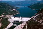 | ||
| Lake Koocanusa Bridge |  MT 37 MT 37 | 48°21′57″N 115°19′31″W / 48.3658°N 115.3252°W / 48.3658; -115.3252 |  | ||
| Highway Bridge | MT 37 | Libby, Montana | 48°23′48″N 115°32′52″W / 48.3966°N 115.5477°W / 48.3966; -115.5477 | ||
| Kootenai Falls Swinging Bridge | Footbridge | Kootenai Falls, Montana | 48°27′12″N 115°46′17″W / 48.4532°N 115.7715°W / 48.4532; -115.7715 | 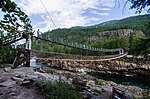 | |
| Theodore Roosevelt Memorial Bridge | Roosevelt Parkway | Troy, Montana | 48°28′12″N 115°53′11″W / 48.47°N 115.886389°W / 48.47; -115.886389 | 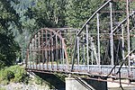 | |
| Kootenai River Bridge |  US 2 US 2 | 48°29′42″N 115°55′04″W / 48.4951°N 115.9179°W / 48.4951; -115.9179 | |||
| Highway Bridge | Leona Road | Near Leona, Idaho (In Montana near MT-ID border.) | 48°37′02″N 116°02′54″W / 48.6171°N 116.0482°W / 48.6171; -116.0482 | ||
| Bonner's Ferry Bridge |  US 2 / US 95 US 2 / US 95 | Bonners Ferry, Idaho | 48°41′59″N 116°18′48″W / 48.6998°N 116.3132°W / 48.6998; -116.3132 | ||
| Kootenay crosses U.S.-Canada border | |||||
| Kootenay River Bridge | Hwy 3 | Near Creston, British Columbia | 49°07′02″N 116°34′50″W / 49.1173°N 116.5805°W / 49.1173; -116.5805 | ||
| Kootenay Lake Ferry |  Hwy 3A Hwy 3A | Connecting Kootenay Bay and Balfour, British Columbia | 49°39′07″N 116°54′41″W / 49.65200°N 116.9115°W / 49.65200; -116.9115 |  | |
| Harrop Cable Ferry | Harrop, British Columbia | 49°36′34″N 117°03′15″W / 49.6095°N 117.0541°W / 49.6095; -117.0541 | |||
| Nelson Bridge (Big Orange Bridge) | Hwy 3A | Nelson, British Columbia | 49°30′37″N 117°16′56″W / 49.5103°N 117.2821°W / 49.5103; -117.2821 |  | |
| Taghum Bridge |  Hwy 3A / Hwy 6 Hwy 3A / Hwy 6 | Taghum, British Columbia | 49°29′40″N 117°22′46″W / 49.4944°N 117.3795°W / 49.4944; -117.3795 | ||
| Corra Linn Dam | Corra Linn, British Columbia | 49°28′05″N 117°28′03″W / 49.4680°N 117.4675°W / 49.4680; -117.4675 | 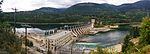 | ||
| Upper Bonnington Falls Dam | Bonnington Falls, British Columbia | 49°27′32″N 117°29′09″W / 49.4588°N 117.4858°W / 49.4588; -117.4858 | |||
| Lower Bonnington Falls Dam | 49°27′39″N 117°29′59″W / 49.4609°N 117.4998°W / 49.4609; -117.4998 | ||||
| Blewett Road | Near South Slocan, British Columbia | 49°27′32″N 117°30′33″W / 49.4590°N 117.5092°W / 49.4590; -117.5092 | |||
| South Slocan Dam | 49°27′23″N 117°31′05″W / 49.4563°N 117.5181°W / 49.4563; -117.5181 | ||||
| Glade Ferry | Tarry's, British Columbia | 49°23′42″N 117°32′40″W / 49.395126°N 117.544426°W / 49.395126; -117.544426 | |||
| Brilliant Dam | Near Brilliant, British Columbia | 49°19′28″N 117°37′10″W / 49.3244°N 117.6195°W / 49.3244; -117.6195 |  | ||
| Brilliant Suspension Bridge | Footbridge | 49°19′03″N 117°37′47″W / 49.3175°N 117.6297°W / 49.3175; -117.6297 | 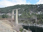 | ||
| Brilliant Bridge | Hwy 3A | 49°19′00″N 117°37′52″W / 49.3168°N 117.6311°W / 49.3168; -117.6311 | 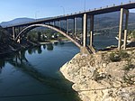 | ||
| References: ACME Mapper[1][failed verification] | |||||
See also
 Transport portal
 Engineering portal
 United States portal
 Canada portal


- List of crossings of the Columbia River
- List of British Columbia-related topics
- List of Montana-related topics
- List of Idaho-related topics
References
- ^ USGS Topo Maps for United States (Map). Cartography by United States Geological Survey. ACME Mapper. Retrieved 2010-03-28.
Map all coordinates using OpenStreetMap
Download coordinates as:
- KML
- GPX (all coordinates)
- GPX (primary coordinates)
- GPX (secondary coordinates)


