Jalapa, Nepal
Former Village Development Committee in Nepal
Village Development Committee in Sagarmatha Zone, Nepal
Jalapa, Nepal जाल्पा | |
|---|---|
Village Development Committee | |
| 27°19′N 86°47′E / 27.31°N 86.78°E / 27.31; 86.78 | |
| Country |  Nepal Nepal |
| Zone | Sagarmatha Zone |
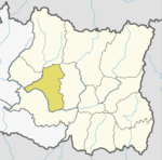
| District | Khotang District |
| Population (1991) | |
| • Total | 2,351 |
| Time zone | UTC+5:45 (Nepal Time) |
Jalapa is a village and also the Village Development Committee of Khotang District in the Sagarmatha Zone of eastern Nepal is located here. At the time of the 1991 Nepal census, it had a population of 2,351 persons living in 448 individual households.[1]
Jalapa consists of other villages such as Kharbari, Purano Gau and Ghale Gau. Most maps of Nepali does not indicate these villages.
References
- ^ "Nepal Census 2001". Nepal's Village Development Committees. Digital Himalaya. Archived from the original on 12 October 2008. Retrieved 30 September 2008.
2. Administrative area of Jalapa (Nepal)
External links
- UN map of the municipalities of Khotang District
- Kharmi
- Dumi language
- v
- t
- e
Khotang District
Headquarters: Diktel
- Rupakot Majhuwagadhi
- Halesi Tuwachung
For former VDCs See here
 | This article about a location in Khotang District, Nepal is a stub. You can help Wikipedia by expanding it. |
- v
- t
- e


