Henveiru
District of Malé in Maldives
Henveiru ހެންވޭރު | |
|---|---|
District of Malé | |
| Country | Maldives |
| Government | |
| • Council | Malé City Council |
| Time zone | UTC+05:00 (MST) |
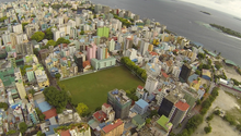
Henveiru (Dhivehi: ހެންވޭރު) is a district of Malé, Maldives.[1][2] It is located to the east of Malé Island, and has an estimated area of 59 hectares and 27,254 inhabitants according to projections for 2014. It is also the largest district on Malé Island.[3]
Location within Malé City
Henveiru is on the eastern portion of Malé Island:
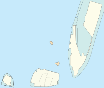
Malé
Hen.
Gal.
Mac.
Maa.
5 Villingili
6 Hulhumalé
← Gulhi Falhu
Dho.
Fun.
Malé Island:
Gal. = 1 Galolhu
Hen. = 2 Henveiru
Maa. = 3 Maafannu
Mac. = 4 Machchangolhi
not part of Malé City:
Dho. = Dhoonidhoo (Prison Island)
Fun. = Funadhoo
Notable Places
- Artificial Beach
- Henveiru Sahara (Cemetery)
- Henveiru Stadium
- Hukuru Miskiy (Friday Mosque)
- Islamic Centre
- King Salman Mosque
- Lonuziyaaraiy Park
- Maldives Police Service
- Muliaage
- People’s Majlis
- President’s Office
- Republic Square
- Sinamalé Bridge
- Victory Monument
References
- v
- t
- e


