Handa Island
Island off the west coast of Sutherland, Scotland
309 hectares (1+3⁄16 sq mi)

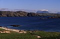
Handa Island (Scottish Gaelic: Eilean Shannda) or usually Handa, is an island in Eddrachillis Bay off the west coast of Sutherland, Scotland. It is 309 hectares (760 acres)[2] and 123 metres (404 ft) at its highest point.[6]
The island is of national importance for its birdlife and maritime vegetation, and is a Scottish Wildlife Trust nature reserve, a Site of Special Scientific Interest (SSSI), and a Special Protection Area (SPA).[7][8] Handa also forms part of the North-West Sutherland national scenic area, one of 40 such areas in Scotland.[9]
A small ferry sails to Handa from Tarbet on the mainland and boat trips operate to it from Fanagmore. The island receives five thousand visitors per annum.[10]
Etymology
The island's name is of mixed Gaelic and Norse origin. The Norse name was Sandey meaning "sand isle" from Old Norse: sandr.[11] It was recorded in Joan Blaeu's 1654 Atlas of Scotland as "Ellan-Handey"[11] with the addition of the Gaelic Eilean (meaing simply "island") and the Norse form having become Handey and ultimately "Handa" due to due to aspiration in Gaelic.[12] MacBain and Haswell-Smith support the derivation of "sand isle"[1][2], although Mac an Tàilleir translates the modern Gaelic of Eilean Shannda as "island at the sandy river".[13][Note 1]
Geography and geology

Handa is composed of Torridonian red sandstone[2] and surrounded by cliffs covered with birds. In the north is a hill with two peaks, with the south and east being lower lying. The north and west have 100-metre-high (330 ft) cliffs, and there are beaches in the south and east. The Sound of Handa separates it from the mainland and smaller islands around Handa include Glas-Leac to the south, Eilean an Aigeach to the north east and Stac an t-Sealbhaig to the north.
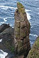
The Great Stac of Handa was first climbed in 1876 by Donald McDonald,[14] a native of St Kilda,[15] who crosssed the 24m gap between the stack and Handa "swinging hand-over hand from a rope".[10] It was first climbed from the sea in August 1969 by Graeme Hunter, Hamish MacInnes and Douglas Lang.[16] The height of the stack, which is one of the tallest in Scotland, is variously recorded as 72 metres (236 ft),[17] "about 107m"[18] and 115m.[10] The nearby Stacan Geodh Bhrisidh is 40 metres (130 ft) high[19] and was also first climbed by that trio in the same year.[18]
Flora and fauna
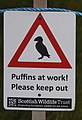
Handa is noted for its birdlife, which includes puffins, razorbills and guillemots. The SPA designation lists six priority species: fulmar, great skua, guillemot, kittiwake, and razorbill.[20] The breeding colonies of razorbills and guillemots on Handa are the largest in the UK, representing 11% and 9% of the total British population respectively. The arctic skua and kittiwake populations are also of national importance, representing >1% and 2% of the British population respectively.[21] Other birds at Handa include eider ducks and oystercatchers, and seals and otters can often be seen at Boulder Bay on the island's southern coast. Dolphins, basking sharks and several species of whale regularly visit the seas surrounding Handa.[22]
Handa is also of national importance for its maritime vegetation. The exposed cliff tops are home to maritime grassland species that can tolerate salt, such as thrift, sea plantain and Festuca rubra. In less exposed areas can be found herb-rich grasslands which support species such as Yorkshire fog, bluebell and Scots lovage. Heather and crowberry are also widespread across the island.[21]
History
In the past the island was used as a burial place, and there are still the remains of a chapel in the south east, commemorated in the name Tràigh an Teampaill (Beach of the Temple). The use of Handa as burial place is thought to be due to the fact that wolves would dig up graves on the mainland so frequently that the inhabitants of Eddrachillis resorted to burying their dead on the island:[23]
- On Ederachillis’ shore
- The grey wolf lies in wait,—
- Woe to the broken door,
- Woe to the loosened gate,
- And the groping wretch whom sleety fogs
- On the trackless moor belate.
- Thus every grave we dug
- The hungry wolf uptore,
- And every morn the sod
- Was strewn with bones and gore:
- Our mother-earth had denied us rest
- On Ederchaillis’ shore
— The Book of Highland Minstrelsy, 1846[24]
It had a population of 65 in 1841[2] butfollowing the 1847 Highland Potato Famine the inhabitants emigrated to Nova Scotia.[22] In some ways this is surprising, since it is recorded that the islanders had a fairly varied diet including oats, fish and seabirds, rather than depending heavily on a potato crop. The islanders had a parliament, similar to that of St Kilda, which met daily, and the oldest widow on the island was considered its "Queen".[2]
The island is now part of the Scourie Estate, owned by Dr Jean Balfour (until her 2023 death) and J.C. Balfour.[25] The Balfours leased Handa to the RSPB for 25 years, however this lease was not renewed, because the Balfours wished a Scottish-based body to run the island; as a result the Scottish Wildlife Trust (SWT) took it over.[2] Under the SWT the island is managed by one warden and a handful of volunteers during the summer months.[26]
Gallery
-
 Stacah Geodh Bhrisidh
 -
 Northern fulmar (Fulmarus glacialis) at Handa Island
 -
 Puffin (Fratercula arctica) at Handa Island
 -
 Great skua (Stercorarius skua) at Handa Island
 -
 Sign for the breeding birds' protected area
 -


See also
 Scottish islands portal

Notes
Footnotes
- ^ a b MacBain 1922, p. 15.
- ^ a b c d e f g Haswell-Smith 2004, p. 199.
- ^ Area and population ranks: there are c. 300 islands over 20 ha in extent and 93 permanently inhabited islands were listed in the 2011 census.
- ^ General Register Office for Scotland (28 November 2003) Scotland's Census 2001 – Occasional Paper No 10: Statistics for Inhabited Islands. Retrieved 26 February 2012.
- ^ Haswell-Smith 2004, pp. 199–201.
- ^ a b c "Handa Island". Ordnance Survey. Retrieved 15 February 2020.
- ^ "Handa Island SSSI". Scottish Natural Heritage. Retrieved 13 May 2019.
- ^ "Handa SPA". Scottish Natural Heritage. Retrieved 13 May 2019.
- ^ "National Scenic Areas" Archived 11 March 2017 at the Wayback Machine. SNH. Retrieved 30 Mar 2011.
- ^ a b c Haswell-Smith 2004, p. 201.
- ^ a b Gammeltoft 2006, p. 77.
- ^ Crawford 1987, p. 97.
- ^ Mac an Tàilleir 2003, p. 61.
- ^ "Handa Island, In more detail". northcoastseatours. Retrieved 23 January 2021.
- ^ Mellor 2020, p. 9.
- ^ "Doug Lang". The Herald. (18 May 2011) Retrieved 6 August 2013.
- ^ "Great Stac of Handa". Themountainguide.co.uk. Retrieved 30 March 2024.
- ^ a b Mellor 2020, p. 149.
- ^ "Stac a'Bhrisidh". Themountainguide.co.uk. Retrieved 30 March 2024.
- ^ "Site Details for Handa SPA". Scottish Natural Heritage. 2 May 2018. Retrieved 16 May 2018.
- ^ a b "Handa Island SSSI Citation". Scottish Natural Heritage. Retrieved 13 May 2019.
- ^ a b "Handa Island Wildlife Reserve: Visitor Leaflet" (PDF). Scottish Wildlife Trust. Retrieved 14 May 2019.
- ^ Wildlife in Britain and Ireland by Richard Perry, published by Taylor and Francis, 1978
- ^ Ogilvy, Eliza Ann H. (1846) The Book of Highland Minstrelsy. G.W. Nickisson. pp. 256-58
- ^ "Property Page: Scourie Estate". Who Owns Scotland. Retrieved 13 May 2019.
- ^ "Handa Island reserve". Retrieved 28 March 2013.
References
- Crawford, Barbara E. (1987). Scandinavian Scotland. Leicester University Press. ISBN 0-7185-1197-2.
- Gammeltoft, Peder (2006). "Scandinavian influence on Hebridean island names". In Gammeltoft, Peder; Jorgenson, Bent (eds.). Names through the Looking-Glass. Copenhagen: C.A. Reitzels Forlag. ISBN 8778764726.
- Haswell-Smith, Hamish (2004). The Scottish Islands. Edinburgh: Canongate. ISBN 978-1-84195-454-7.
- Mac an Tàilleir, Iain (2003). "Ainmean-àite/Placenames". Pàrlamaid na h-Alba. Retrieved 26 August 2012.
- MacBain, Alex (1922). Place Names: Highlands and Islands of Scotland. Stirling: Eneas MacKay. ISBN 0-7185-1197-2.
- Mellor, Chris (January 2020). "Stack Rock 2020: An illustrated guide to sea stack climbing in the UK & Ireland" (PDF). needlesports. Retrieved 23 January 2021.
External links
Wikimedia Commons has media related to Handa Island.
- Scottish Wildlife Trust - Handa Island
- More information and photos Archived 26 February 2021 at the Wayback Machine at the Handa Island Skua Project
- v
- t
- e
Uninhabited islands of the Hebrides
- Calbha Beag
- Calbha Mor
- Calve Island
- Cara
- Càrna
- Eileach an Naoimh
- Eilean an Ròin Mòr
- Eilean Dubh Mòr
- Eilean Fladday
- Eilean Horrisdale
- Eilean Ighe
- Eilean Macaskin
- Eilean Meadhonach
- Eilean Mhic Chrion
- Eilean Mòr
- Eilean Rìgh
- Eilean Tigh
- Eilean Trodday
- Eorsa
- Garbh Eileach
- Gruinard
- Gunna
- Handa
- Harlosh Island
- Horse Island
- Inch Kenneth
- Insh
- Isay
- Isle Martin
- Isle Ristol
- Little Colonsay
- Longa Island
- Longay
- Lunga
- Oldany Island
- Ornsay
- Oronsay
- Pabay
- Priest Island
- Scarba
- Shuna
- Staffa
- Tanera Beag
- Texa
- Torsa
- Wiay

- Barra Head
- Boreray
- Calbhaigh
- Ceabhaigh
- Ceallasaigh Beag
- Ceallasaigh Mòr
- Ceann Ear
- Ceann Iar
- Eilean Chaluim Chille
- Eilean Chearstaidh
- Eileanan Iasgaich
- Eilean Liubhaird
- Eilean Mhealasta
- Eilean Mhuire
- Ensay
- Fiaraidh
- Flodaigh
- Flodaigh Mòr
- Flodday
- Flodday
- Fodragaigh
- Fuaigh Beag
- Fuaigh Mòr
- Fuday
- Fuiay
- Garbh Eilean
- Gasker
- Gighay
- Groaigh
- Haskeir
- Haskeir Eagach
- Hellisay
- Hermetray
- Killegray
- Kirkibost
- Lingeigh
- Little Bernera
- Mingulay
- Muldoanich
- Orosay
- Oronsay
- Pabbay
- Pabaigh Mòr
- Ronay
- Sandray
- Scarp
- Seaforth Island
- Sgeotasaigh
- Sibhinis
- Shillay
- Soay Mòr
- Stromay
- Stockinish Island
- Stuley
- Sursaigh
- Tahay
- Taransay
- Trialabreac
- Torogaigh
- Vacsay
- Vallay
- Wiay
| |||||||||||||||||
|---|---|---|---|---|---|---|---|---|---|---|---|---|---|---|---|---|---|
|  | ||||||||||||||||
|
| |||||||||||||||||
| |||||||||||||||||
| |||||||||||||||||
| |||||||||||||||||
| |||||||||||||||||
| |||||||||||||||||
| |||||||||||||||||
58°22′51″N 5°11′11″W / 58.38083°N 5.18639°W / 58.38083; -5.18639


