Expressway S79 (Poland)
You can help expand this article with text translated from the corresponding article in Polish. Click [show] for important translation instructions.
- Machine translation, like DeepL or Google Translate, is a useful starting point for translations, but translators must revise errors as necessary and confirm that the translation is accurate, rather than simply copy-pasting machine-translated text into the English Wikipedia.
- Do not translate text that appears unreliable or low-quality. If possible, verify the text with references provided in the foreign-language article.
- You must provide copyright attribution in the edit summary accompanying your translation by providing an interlanguage link to the source of your translation. A model attribution edit summary is
Content in this edit is translated from the existing Polish Wikipedia article at [[:pl:Droga ekspresowa S79 (Polska)]]; see its history for attribution. - You may also add the template
{{Translated|pl|Droga ekspresowa S79 (Polska)}}to the talk page. - For more guidance, see Wikipedia:Translation.
 | ||||
|---|---|---|---|---|
| Droga ekspresowa S79 | ||||
 | ||||
| Route information | ||||
| Length | 4.8 km (3.0 mi) plus 2 km (1.2 mi) concurrent with Expressway S2 | |||
| Major junctions | ||||
| From | Warszawa–Marynarska junction (Warsaw) | |||
| To | Warszawa–Puławska junction (Warsaw) | |||
| Location | ||||
| Country | Poland | |||
| Major cities | Warsaw | |||
| Highway system | ||||
| ||||
| ||||


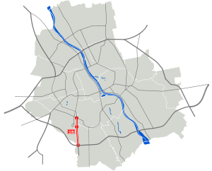
Expressway S79 is an expressway in Warsaw acting as a spur route between the southern S2 Expressway section of the Warsaw Express Ring Road at Warszawa Południe junction and Int. Frederic Chopin Airport, ending at the junction with the inner-city Marynarska road. On a stretch between Warszawa Południe and Warszawa–Puławska junctions, S79 has concurrency with S2.
The road was completed in September 2013 and in the future will act as a major Warsaw exit route to the S7 Expressway towards Kraków.
Exit list
| Country | Voivodeship | Location | km | mi | Exit | Name | Destinations | Notes |
|---|---|---|---|---|---|---|---|---|
| Poland | Mazovian Voivodeship | Warsaw | 0 | 0.0 | — | Marynarska |  DK 79 – ul. Sasanki, Ursus, Centrum DK 79 – ul. Sasanki, Ursus, Centrumul. Marynarska – Mokotów | Northwestern endpoint of expressway, planned continuation as N-S route Centrum means city centre Kilometrage starting point Access to Marynarska Street (Polish: ulica Marynarska) and Sasanki Street (Polish: ulica Sasanki) There are no signs with the name of the junction |
| 1.5 | 0.93 | — | Warszawa Okęcie | local road – Warsaw Chopin Airport | There are no signs with the name of the junction | |||
| 4.6 | 2.9 | — | Warszawa Lotnisko |   S 2 / E30 – Poznań S 2 / E30 – Poznań S 7 – (under construction) S 7 – (under construction) | West terminus of common section with S2 S7 under construction | |||
| R12 | Puławska | S 2 / E30 – Terespol, Lublin, Wawer DK 79 – ul. Puławska, Piaseczno, Sandomierz / Ursynów, Mokotów | • Southeast endpoint of the expressway • East terminus of common section with S2 Access to Puławska Street (Polish: ulica Puławska) Exit number of expressway S2 | |||||
1.000 mi = 1.609 km; 1.000 km = 0.621 mi
| ||||||||
External links
- Warszawski węzeł komunikacyjny/obwodnica miasta
- v
- t
- e

- A1
- A2
- A4
- A6
- A8
- A18
- A50

- S1
- S2
- S3
- S5
- S6
- S7
- S8
- S10
- S11
- S12
- S14
- S16
- S17
- S19
- S22
- S50
- S51
- S52
- S61
- S74
- S79
- S86
- 1
- 2
- 3
- 4
- 5
- 6
- 7
- 8
- 9
- 10
- 11
- 12
- 13
- 14
- 15
- 16
- 17
- 18
- 19
- 20
- 21
- 22
- 23
- 24
- 25
- 26
- 27
- 28
- 29
- 30
- 31
- 32
- 33
- 34
- 35
- 36
- 37
- 38
- 39
- 40
- 41
- 42
- 43
- 44
- 45
- 46
- 47
- 48
- 49
- 50
- 51
- 52
- 53
- 54
- 55
- 56
- 57
- 58
- 59
- 60
- 61
- 62
- 63
- 64
- 65
- 66
- 67
- 68
- 70
- 71
- 72
- 73
- 74
- 75
- 76
- 77
- 78
- 79
- 80
- 81
- 82
- 83
- 84
- 85
- 86
- 87
- 88
- 89
- 90
- 91
- 92
- 93
- 94
- 95
- 96
- 97
- A3
- A12
- A41
- S47
- S69
- 69
- 98
51°43′36″N 21°23′40″E / 51.726682°N 21.394400°E / 51.726682; 21.394400
 | This Polish road or road transport-related article is a stub. You can help Wikipedia by expanding it. |
- v
- t
- e


